Specialisation Studies | Vastavikta Bhagat
Drawing Out Futures
What does one draw and how does one methodologically approach the act of drawing to move beyond cartographic frames of imagining urban neighborhoods and the speculations that come to address them?
The studio this semester began with this underlying question to think through two neighborhoods along the Dahisar river, where the flood, pollution and informal housing are a common set of ‘problems’ that are framed by the state. Two ways of approaching this drawing question were put forth in the first week. While one worked with GIS, gazettes and archival maps prepared by the colonial enterprise and the state, the other involved walking along the river, collecting stories and maintaining a journal of the site to hold its lived experiences, perceptions and gossip.
A network map of Kandarpada opened up how the ownership titles and types of tenancy produced the urban form of the gaothan as well as was consequential in influencing the multiple futures that would get produced within the neighborhood in fragmented ways. The inhabitants of the neighborhood perceived the site based on where they situated themselves in the chain of tenure, where stories of the past of rice fields, fishing and private wadis intermingled with stories of migration and making home in chawls within the spatiality of Kandarpada. These perceptions then became the strategy to draw where the collapsing of time and accrual of narratives formed the map.
![]()
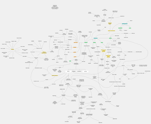
Network map of Kandarpada
The constellation as a form of network drawing opened up ambawadi as a porous market of transactional capacities that held diverse agencies beyond the chawl maliks and landowners that were renting out the single room tenements in the neighborhood. The site as a space of the market holding its inhabitants beyond the geo-spatial logic of adjacencies became the crux to the exercise of drawing the neighborhood and speculating.
![]()
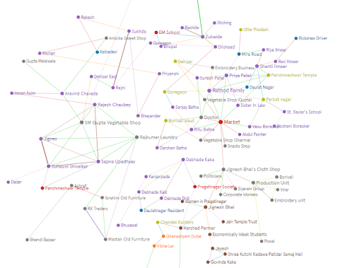
Network map of Ambawadi
Two spatial drawings that moved beyond the cartographic map of the sites emerged when one layered the network map, journal and stories. The drawing of Kandarpada tied type, tenure and social spaces and the drawing of Ambawadi emerged from the market as a porosity. These then became the canvas for community consultations where one could read more than human and human beings engaging with infrastructures, spaces of living and working, objects and each other to form a complex mesh of alliances and (non) dependencies. These drawings further became the basis on which speculations were done based on the gossips and perceptions collected, where immediate and far spatial speculations were drawn out and how these would implicate the current form of the neighborhoods and the networks.

Neighbourhood drawing of Kandarpada

Neighbourhood drawing of Ambawadi
The accrual of the layers of time in the future up till 2050 on the neighborhood maps allowed the studio to look at the sites softly and questioned notions of intervention and the extent of the same. The groups emerged with strategies of conservative surgery, repair and retrofit and small incremental cluster development which worked towards retaining the lifespaces.

Kandarpada, 2027 Speculation

Kandarpada, 2034 Speculation

Kandarpada, 2050 Speculation