Sem 06 | Settlement Studies
Landscape Understanding of Space through the Lens of Ecological Environmentalism
Every year Settlement Studies is the most awaited module of the year. It needs many preparations to shortlist the site, organize accomodation and to plan the travel. That time of the year when everyone packs their bags, stocks food and gets ready for a week away from home on the field. However, this year was very different. We were locked up in our houses and were unable to visit the field despite the strong urge to transcend the house's four walls. The settlement studies module needed a complete rethinking; newer strategies were required to be formulated to make sure the physical disconnect with the site was bridged.
The site was located in Murbad Village in Dahanu. Students had visited this site in their first year for an hands-on activity and hence could identify with it in bits and parts from their memories. This year, onboard with us, we had the Design Jatra team, a design practice who intimately engage and work in this region and who became our eyes and the ears on-site. Their team conducted a series of investigations on site for the studio. They introduced to the physical and regional terrain, the larger ecosystems and regional frameworks, along with flora and fauna, stories and cultural practices of the region. The students thus set foot on the site virtually through secondary information sources.
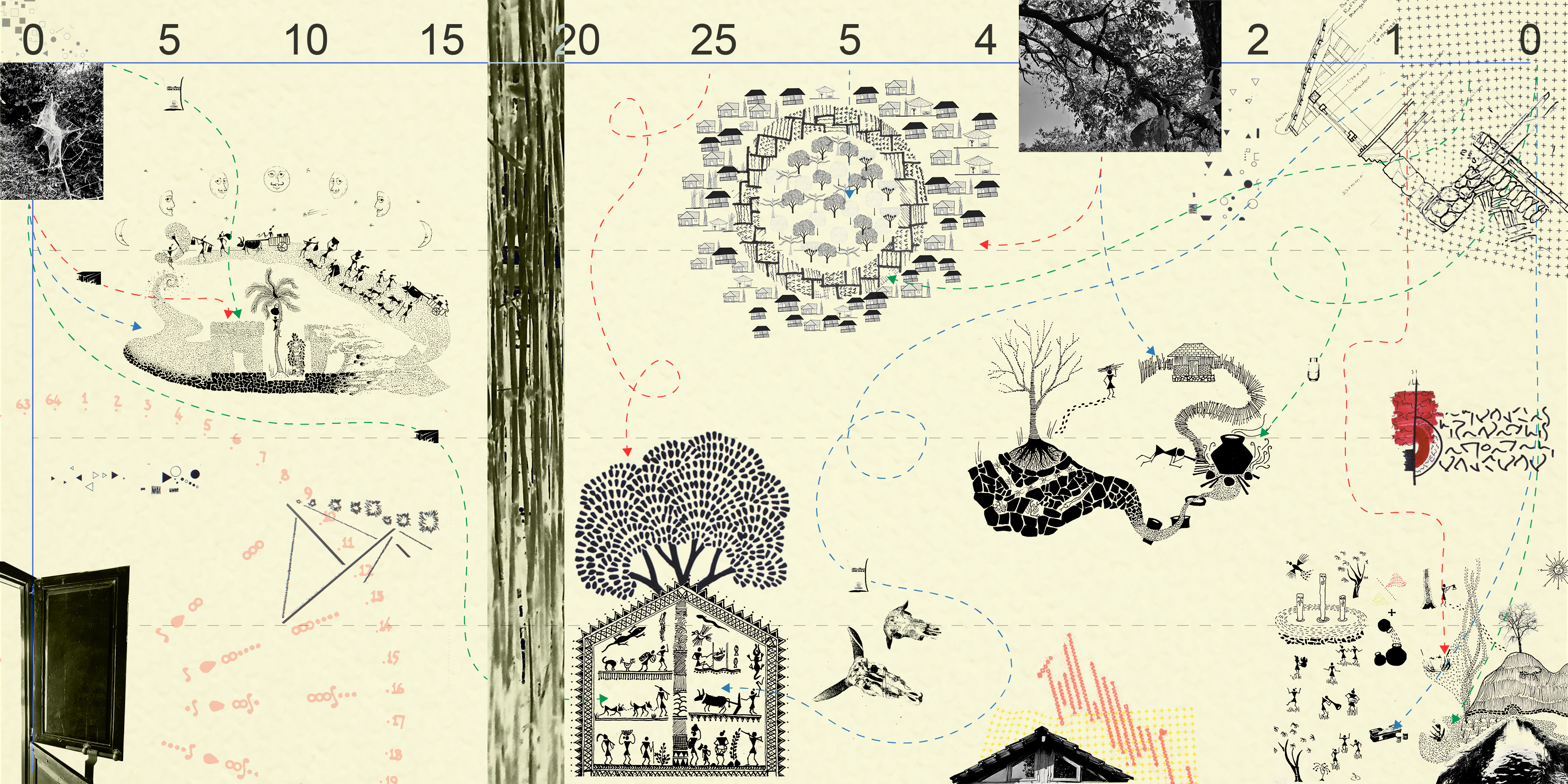
Site Documentation also needed to be rethought as getting factual information was difficult as the stories and narratives of the site were built like the game of chinese whispers. Parts and portions of perceptions were stitched together. The class was divided into ten groups each focusing on a particular lens to work out the perception maps. Thus the entire narrative of murbad was stitched together through 10 fragments of perceptions. The students started building up perception maps for the village with video walkthroughs, phone interviews, recordings, and secondary documentation.
The site was located in Murbad Village in Dahanu. Students had visited this site in their first year for an hands-on activity and hence could identify with it in bits and parts from their memories. This year, onboard with us, we had the Design Jatra team, a design practice who intimately engage and work in this region and who became our eyes and the ears on-site. Their team conducted a series of investigations on site for the studio. They introduced to the physical and regional terrain, the larger ecosystems and regional frameworks, along with flora and fauna, stories and cultural practices of the region. The students thus set foot on the site virtually through secondary information sources.
Site Documentation also needed to be rethought as getting factual information was difficult as the stories and narratives of the site were built like the game of chinese whispers. Parts and portions of perceptions were stitched together. The class was divided into ten groups each focusing on a particular lens to work out the perception maps. Thus the entire narrative of murbad was stitched together through 10 fragments of perceptions. The students started building up perception maps for the village with video walkthroughs, phone interviews, recordings, and secondary documentation.
The experience was turbulent at times, and all the frustrations emerged as one could not physically visit the site and experience the terrain and the context. The very foundation of the field study to be able to sense and experience the space was reconfigured. The students constructed perception maps for various lens ranging from built form cycles, ecological cycles, ground and terrain transformations, occupation and economic cycles, socio-cultural activities and life. Smaller stories of the village were stitched together to generate an extensive understanding of the region. The narratives were then fused with visual expressions to construct the visual experience of the site through drawings, photos and carefully constructed maps.
The studio's focused study was to enter into an environmentally sensitive and rich terrain to understand ecological cycles and their dependencies. Further, to understand the impact of human activities and their positioning in this larger cycle. The study of murbad unfolded many inter-related cycles, the socio-cultural activities and how they were framed in the ecology cycle, how the sacred grooves and the forest gave rise to particular rituals and myths, the self-sustaining cycles of materials & thus the lifecycle of the built form. Individual fragmented perception maps thus became part of the whole to generate the larger image of the region.
The studio's focused study was to enter into an environmentally sensitive and rich terrain to understand ecological cycles and their dependencies. Further, to understand the impact of human activities and their positioning in this larger cycle. The study of murbad unfolded many inter-related cycles, the socio-cultural activities and how they were framed in the ecology cycle, how the sacred grooves and the forest gave rise to particular rituals and myths, the self-sustaining cycles of materials & thus the lifecycle of the built form. Individual fragmented perception maps thus became part of the whole to generate the larger image of the region.

Cycles and Rythyms- A Perception map by Samruddhi Pawar and Riddhi Shah
As geography and seasons have a unique cycle in terms of time and space changes, built form in this region also have their own cycles. The material cycles are fused with the cycles of construction of built form and use of space. These rhythms thus hold the balance of material flows together. The bamboo and teak from the forest is harvested and processed to use in the built form which then serves its life in the built form to further be reused for another activity. Each of the built is deconstructed and reconstructed in cyclic time.
![]()
Biodiversity - A perception map by Charmi Mehta and Ashwini Borkar
This map was constructed to lay out the understanding of flora in the region. The biodiversity cycles are altered by various natural and manmade processes and activities. This map thus carefully constructed the dependence and exchange of processes within the cyclic time for the inhabited flora of the region. The practices of rice farming and the vegetation in the region were carefully plotted with respect to the geographical terrain. Flora cycles were also a result of overgrazing of land by fauna in the region ,ground water and climatic variations.
![]() Permanence as Decaying - A perception map by Diwakar Motwani and Ninad Thatte
Permanence as Decaying - A perception map by Diwakar Motwani and Ninad Thatte
The narrative seeks to instill the idea of permanence for the villagers, who believe it's a cycle rather than an object's or building's lifespan. The drawing identifies the interjections in these cycles and illustrates the clash between the "villager's conviction" and the "interjections", as well as the vital impact these have on the forest or resources.
As geography and seasons have a unique cycle in terms of time and space changes, built form in this region also have their own cycles. The material cycles are fused with the cycles of construction of built form and use of space. These rhythms thus hold the balance of material flows together. The bamboo and teak from the forest is harvested and processed to use in the built form which then serves its life in the built form to further be reused for another activity. Each of the built is deconstructed and reconstructed in cyclic time.

Biodiversity - A perception map by Charmi Mehta and Ashwini Borkar
This map was constructed to lay out the understanding of flora in the region. The biodiversity cycles are altered by various natural and manmade processes and activities. This map thus carefully constructed the dependence and exchange of processes within the cyclic time for the inhabited flora of the region. The practices of rice farming and the vegetation in the region were carefully plotted with respect to the geographical terrain. Flora cycles were also a result of overgrazing of land by fauna in the region ,ground water and climatic variations.
 Permanence as Decaying - A perception map by Diwakar Motwani and Ninad Thatte
The narrative seeks to instill the idea of permanence for the villagers, who believe it's a cycle rather than an object's or building's lifespan. The drawing identifies the interjections in these cycles and illustrates the clash between the "villager's conviction" and the "interjections", as well as the vital impact these have on the forest or resources.

The investigation start with the question of what a forest is ? This question dismantled the popular perception of forest as “Wilderness” and also rethinks the ontological enquiry of the home, “The human habitat” and “Civility”. This narrative opened up vivid realms of density, habitat, survival and celebrations. The norms laid down by the spirit of the forest ever since. The prey is not merely a beast, but a fellow of the forest which has to be treated with the same respect as they would treat the other humans. Stories of mythical characters and forest spirits establish the symbiotic relationship very firmly and there are codes of conduct as if a forest is independently administered just like a city. Hunting would take place at night and the hunters would live in the deepest of the forests during the day. One can find small shacks made out of branches and leaves in the hearth of the forest even today. Naturally, this realm of the deep forest is the least frequented amongst all three. But by no means is it perceived as “wild” as it bears a resemblance to their cultivated or domesticated surroundings. In committing to the acts of cultivation and extraction for the forests, the people leave a mark on the forests. However, the impacts of their actions are very barely detectable. These impacts are essentially periodical shifts in the habitats of birds, animals, insects and vegetation. The narrative was beautifully constructed over the landscape of the terrain and drawing visual inspiration from Ajanta Cave paintings.
Myths and Stories - A perception map by Rishabh Chajjar and Paras Burande